Flooding in Niigata and Fukushima Prefectures: More than 400,000 people urged to leave their homes – One dead and five missing


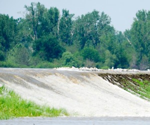
More than 400,000 people were urged to leave their homes amid flooding in Niigata and Fukushima prefectures [AFP]

Floods threaten thousands in northern Japan (Al Jazeera, July 30, 2011):

One dead and five missing as heavy rains burst rivers and dykes in Niigata and tsunami-hit Fukushima prefectures.

Heavy rains have claimed their first victim in Japan, where the government has urged nearly half a million people to leave their homes amid flooding in the northern Niigata and tsunami-hit Fukushima prefectures.

River banks gave way to swollen rivers at several points on Saturday and more than 400,000 people were advised to head to evacuation centres.

As Al Jazeera’s Aela Callan reported from Yasuda city in Niigata prefecture, the worst-hit towns were swamped by water levels that reached as high as 12 metres. But she said the rain had stopped by midday and authorities predicted that the worst of the rains had ceased.
Read moreFlooding in Niigata and Fukushima Prefectures: More than 400,000 people urged to leave their homes – One dead and five missing

Army Corps Predicts Missouri River To Flow Over Up To 70 Levees

Experts expect more Missouri River levee failures (Kansas City Star, Jul. 09, 2011):

Several hundred thousand acres of rich Midwestern farmland and even some urban areas near the Missouri River are at risk of flooding this summer during months of historically high water that experts fear will overwhelm some levees, especially older ones.

Engineers who have studied past floods say the earthen levees in rural areas are at greater risk.

“Most of the levees are agricultural levees. They’re not engineered. They’re just dirt piled up,” said David Rogers, an engineering professor at Missouri University of Science and Technology.

So far, most levees have held along the 811 miles the Missouri travels from the last dam at Gavins Point in South Dakota to its confluence with the Mississippi River near St. Louis. The flooding thus far has covered more than 560,000 acres of mostly rural land, including nearly 447,000 acres of farmland. The water has forced some evacuations, but the extent of the damage to may not be clear until it recedes.

That’s not expected to happen until the fall as the Army Corps of Engineers says it needs to continue releasing substantial amounts of water from upstream reservoirs inundated with heavy spring rains and melt from an above average Rocky Mountain snowpack.

The Corps predicts that the river will eventually rise high enough to flow over some 18 to 70 levees, mostly in rural areas of southeast Nebraska, southwest Iowa and Missouri. Other levees will become saturated, and water can erode their foundations, seep underneath or find other flaws to exploit.

Read moreArmy Corps Predicts Missouri River To Flow Over Up To 70 Levees

Missouri River Levee Intentionally Blown Up Near Fort Calhoun Nuclear Plant, NO Government Entity Had Anything To Do With The Detonation, Authorities Investigate Detonation

Levee Intentionally Blown Up Along Missouri River (KETV, July 1, 2011):

LOVELAND, Iowa — Authorities are investigating an intentional breach in a levee near Desoto Bend.

Pottawattamie County officials said a half-mile stretch of the Vanmann #30 levee was mechanically excavated and then lowered by using explosives. The private levee is just north of the Boyer Chute National Wildlife Refuge, northwest of Honey Creek.

So far, emergency management officials said they’ve seen no damage as a result of the levee breach, but they have fielded plenty of phone calls about it.

Emergency Management Coordinator Jeff Theulen said he was alerted Friday morning that the levee may have been in the process of being intentionally breached. About 20 minutes later, officials said they received calls from people wanting to know why levees were being blown up. One caller claimed to have witnessed the explosion.

Pottawattamie County officials said no government entity had anything to do with the detonation, and they did not have advance notice from the people responsible for the breach.

Read moreMissouri River Levee Intentionally Blown Up Near Fort Calhoun Nuclear Plant, NO Government Entity Had Anything To Do With The Detonation, Authorities Investigate Detonation

Fukushima Spews, Los Alamos Burns, Vermont Rages & We Almost Lost Nebraska

Fukushima Spews, Los Alamos Burns, Vermont Rages & We Almost Lost Nebraska (Hawaii Daily News, June, 29, 2011):

Humankind is now threatened by the simultaneous implosion, explosion, incineration, courtroom contempt and drowning of its most lethal industry.

We know only two things for certain:  worse is yet to come, and those in charge are lying about it—at least to the extent of what they actually know, which is nowhere near enough.

Indeed, the assurances from the nuke power industry continue to flow like the floodwaters now swamping the Missouri Valley heartland.

But major breakthroughs have come from a Pennsylvania Senator and New York’s Governor on issues of evacuation and shut-down.  And a public campaign for an end to loan guarantees could put an end to the US industry once and for all.

FUKUSHIMA: The bad news continues to bleed from Japan with no end in sight.  The “light at the end of the tunnel” is an out-of-control radioactive freight train, headed to the core of an endangered planet.

Widespread internal radioactive contamination among Japanese citizens around Fukushima has now been confirmed.

Two whales caught some 650 kilometers from the melting reactors have shown intense radiation.

Plutonium, the deadliest substance known to our species, has been found dangerously far from the site.

Read moreFukushima Spews, Los Alamos Burns, Vermont Rages & We Almost Lost Nebraska

The Fort Calhoun Nuclear Plant Bucket Brigade: Nuclear Workers Have To Carry Fuel Cans To Keep Water Pumps Running

Nuclear Plant’s Vital Equipment Dry, Officials Say (New York Times, June 27, 2011):

FORT CALHOUN, Neb. — When safety regulators arrive for a tour of a nuclear plant, the operators usually give the visitors a helmet, safety glasses and earplugs. When Gregory B. Jaczko, chairman of the Nuclear Regulatory Commission, got to the Fort Calhoun plant on Monday morning, the Omaha Public Power District offered him a life jacket.

Read moreThe Fort Calhoun Nuclear Plant Bucket Brigade: Nuclear Workers Have To Carry Fuel Cans To Keep Water Pumps Running

Even In Shutdown Mode Fort Calhoun Nuclear Plant Requires Electricity To Avoid Melting Of The Core


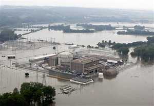
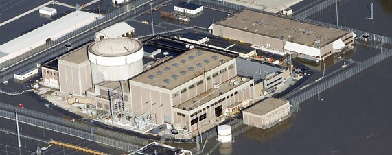
An aerial view of the Fort Calhoun Nuclear Power Plant in eastern Nebraska, surrounded by Missouri River flood waters on June 24.

Waters Encircle Nuclear Plant (Wall Street Journal, June 27, 2011):

A protective berm holding back floodwaters from a Nebraska nuclear power plant collapsed early Sunday after it was accidentally torn, surrounding containment buildings and key electrical equipment with Missouri River overflow.

The berm’s collapse allowed floodwaters to wash around the main electrical transformers. As a result, emergency diesel power generators were started. Later in the day, power was restored.

The NRC’s Mr. Dricks said temperature monitors were working properly and temperatures of key parts of the nuclear power plant were normal. Water has not seeped into any of the containment structures, he said.

Even when in shutdown mode, a nuclear plant requires electricity to keep key components cool in order to avoid any degradation or melting of the core that could result in the release of radiation.

Flood Berm Collapses At Fort Calhoun Nuclear Plant After Being Punctured By Some Sort Of Machinery

Flood berm bursts at Nebraska nuclear plant (CNN, June 27, 2011):

A water-filled berm protecting a nuclear power plant in Nebraska from rising floodwaters collapsed Sunday, according to a spokesman, who said the plant remains secure.

Some sort of machinery came in contact with the berm, puncturing it and causing the berm to deflate, said Mike Jones, a spokesman for the Omaha Public Power District (OPPD), which owns the Fort Calhoun plant.

Read moreFlood Berm Collapses At Fort Calhoun Nuclear Plant After Being Punctured By Some Sort Of Machinery

Fort Calhoun Nuclear Plant: Floodwater Seeps Into Turbine Building At Nebraska Nuke Station

Fort Calhoun Nuclear Plant: Flood Seeps Into Turbine Building At Nebraska Nuke Station (Huffington Post, June 27, 2011):

OMAHA — Missouri River floodwater seeped into the turbine building at a nuclear power plant near Omaha on Monday, but plant officials said the seepage was expected and posed no safety risk because the building contains no nuclear material.

An 8-foot-tall, water-filled temporary berm protecting the plant collapsed early Sunday. Vendor workers were at the plant Monday to determine whether the 2,000 foot berm can be repaired.

Read moreFort Calhoun Nuclear Plant: Floodwater Seeps Into Turbine Building At Nebraska Nuke Station

NRC In 2010: Floods Above 1010 Feet Had A 100 Percent Chance Of Core Meltdown At Fort Calhoun Nuclear Plant – Now: Missouri River Reaches Height Of Nearly 1,007 Feet

A Nuclear Plant’s Flood Defenses Trigger a Yearlong Regulatory Confrontation (New York Times, June 24, 2011):

Pictures of the Fort Calhoun nuclear power plant north of Omaha, Neb., show it encircled by the swollen waters of the Missouri River, which reached a height of nearly 1,007 feet above sea level at the plant yesterday.

The plant’s defenses include new steel gates and other hard barriers protecting an auxiliary building with vital reactor controls, and a water-filled berm 8 feet tall that encircles other parts of the plant. Both systems are designed to hold back floodwaters reaching 1,014 feet above sea level. Additional concrete barriers and permanent berms, more sandbags and another power line into the plant have been added. The plant was shut down in April for refueling and will remain so until the flood threat is passed.

“Today the plant is well positioned to ride out the current extreme Missouri River flooding while keeping the public safe,” Nuclear Regulatory Commission spokesman Victor Dricks said on an agency blog this week.

But a year ago, those new defenses were not in place, and the plant’s hard barriers could have failed against a 1,010-foot flood, the Nuclear Regulatory Commission contends in a yearlong inspection and enforcement action against the plant’s operator, the Omaha Public Power District (OPPD).

The NRC in Action at Fort Calhoun (Monthly Review, June 27, 2011):

The Union of Concerned Scientists often complains about Nuclear Regulatory Commission inaction — the agency’s failure to enforce its regulations prohibiting unmonitored and uncontrolled releases of radioactively contaminated water, the agency’s tolerance of four dozen reactors operating in violation of fire protection regulations, and so on.

Today, we commend the NRC in action.

Read moreNRC In 2010: Floods Above 1010 Feet Had A 100 Percent Chance Of Core Meltdown At Fort Calhoun Nuclear Plant – Now: Missouri River Reaches Height Of Nearly 1,007 Feet

Levee North Of Brownville, Near Cooper Nuclear Plant Fails


Floodwaters from the Missouri river overtop a levy in Brownville, Neb., Sunday, June, 19, 2011. When the Missouri River reached 42.5 feet, or 899 feet above sea level Sunday morning, the Nebraska Public Power District issued a flooding alert for its nuclear power plant, Cooper Nuclear Station. Cooper, located near Brownville, is at 903 feet elevation, and NPPD officials said the river would have to climb to 902 feet at Brownville before officials would shut down the plant. (AP)

Levee breaks north of Brownville (Journal Star, June 23, 2011):

A levee three miles north of Brownville in Missouri failed at about 9 p.m. Thursday, right in front a pair of people patrolling there.

Read moreLevee North Of Brownville, Near Cooper Nuclear Plant Fails

Two Feet Of Water Already Made Its Way To Several Areas Of The Fort Calhoun Nuclear Plant

Although the Fort Calhoun plant is surrounded by an eight foot tall and 16 foot wide protective berm, two feet of water have already made its way to several areas of the Fort Calhoun plant, but authorities say there is no immediate danger at either plant.


Sirens Blare as Flooding Hits North Dakota (ABC News, June 22, 2011):

Sirens are blaring at this moment in Minot, N.D., as the overflowing Souris River floods over the top of local levees five hours before the evacuation deadline for 11,000 residents. Farther south, the overflowing Missouri River has put two nuclear power plants at risk, necessitated evacuations and produced a travel nightmare as interstate highways shut down.

“What I see right now is probably the most devastating in terms of the number of people directly impacted and what will likely be the damage to homes as the water begins to overtop the levees and fill in behind,” National Guard Cmdr. Dave Sprynczynatyk said today.

Nearly 500 North Dakota National Guard soldiers are in the town of 41,000 people to help the last stragglers in the affected area get out of harm’s way. They are accompanying the roaring sirens with shouts of “All residents must evacuate!”

“We’ve never seen anything like what we’re expecting,” Minot Mayor Curt Zimbleman told ABC News. The mayor had warned residents previously today that the river could top the levees earlier than expected, and has been urging residents to leave potentially affected areas.

Read moreTwo Feet Of Water Already Made Its Way To Several Areas Of The Fort Calhoun Nuclear Plant

Nebraska: Record Missouri River Surge – Inches Toward Nuclear Plant Shutdown Level

River inches toward nuke plant shutdown level (Journal Star, June 20, 2011):

The Missouri River rose to record height Sunday at Brownville, prompting Cooper Nuclear Station three miles south of the community to declare a low-level emergency at 2:06 a.m.

NPPD said it would take the plant offline if the water level reached 902 feet above sea level. At 6 p.m., the level was 901.73 feet.

Water levels at the Brownville gauge increased approximately two feet in a 24-hour period from 5:30 a.m. Saturday to 5:30 a.m. Sunday.

?Record River Surge Recorded In Southeast Nebraska (WOWT, Jun 20, 2011):

The Missouri River surged to a new record at Brownville in southeast Nebraska Sunday afternoon as workers have been adding sandbags to the levee.

The National Weather Service said the river measured at 44.75 feet surpassing a record of 44.3 feet set in 1993. Flood stage is 33 feet.

The U.S. Army Corps of Engineers said the river level at Brownville surged two feet from Saturday morning to Sunday morning. Col. Bob Ruch attributed that to heavy rain on the Nishnabotna River, which flows into the Missouri,
and to some erosion along a levee upstream at Hamburg, Iowa, that created a water pulse.

The Nebraska Emergency Management Agency says water was flowing over a levee there and into farmland, but the levee is being built up.

Read moreNebraska: Record Missouri River Surge – Inches Toward Nuclear Plant Shutdown Level

China Raises Flood Alert To Top Level, 555,000 Evacuated

China raises flood alert to top level, 555,000 evacuated (Reuters, Jun 17, 2011):

China has mobilized troops to help with flood relief and raised its disaster alert to the highest level after days of downpours forced the evacuation of more than half a million people in central and southern provinces.

The official China Daily said more than 555,000 people had been evacuated in seven provinces and a municipality after rains in recently drought-stricken areas caused floods and mudslides in the Yangtze River basin.

Read moreChina Raises Flood Alert To Top Level, 555,000 Evacuated

Dear Nebraska: Sorry About Water, But More On The Way. Love, Montana


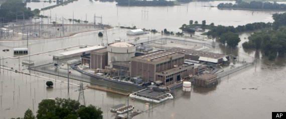
FILE – In this June 14, 2011 file photo, the Fort Calhoun nuclear power station, in Fort Calhoun, Neb., is surrounded by flood waters from the Missouri River. The pictures of a Nebraska nuclear power plant were startling: Floodwaters from the swollen Missouri River had risen nearly to the reactor building, with the potential to climb even higher.

See also:

Floodwaters Might Hit Kansas City By Midweek – Army Corps Running Out Of Options – ‘At This Point, We Have Very Little Flexibility Remaining’


Dear Nebraska: Sorry about water, but more on the way. Love, Montana (JournalStar, June 17, 2011):

From his tackle shop near Three Forks, Mont., Rich Gay is watching three rivers.

They’re running high out of the mountains, skirting his town, fraying his nerves and converging, more than a mile away.

This is the headwaters of the Missouri River — and the source this summer of so much Nebraska pain.

But this isn’t where the flood begins.

Read moreDear Nebraska: Sorry About Water, But More On The Way. Love, Montana

Floodwaters Might Hit Kansas City By Midweek – Army Corps Running Out Of Options – ‘At This Point, We Have Very Little Flexibility Remaining’


FILE – In this June 14, 2011 file photo, the Fort Calhoun nuclear power station, in Fort Calhoun, Neb., is surrounded by flood waters from the Missouri River. The pictures of a Nebraska nuclear power plant were startling: Floodwaters from the swollen Missouri River had risen nearly to the reactor building, with the potential to climb even higher. Coming only a few months after Japan’s nuclear disaster, the Associated Press images alarmed many people who saw them earlier this week. But nuclear regulators and the utility that runs the Fort Calhoun reactor say there is little cause for immediate concern.

Floodwaters might hit KC by midweek (Kansas City Star, June 17, 2011):

Forecasts now say a peak wave of floodwaters from the Missouri River won’t hit the Kansas City area until roughly Wednesday.

But another forecast has drawn concern from the Army Corps of Engineers.

Read moreFloodwaters Might Hit Kansas City By Midweek – Army Corps Running Out Of Options – ‘At This Point, We Have Very Little Flexibility Remaining’

Nebraska Emergency Management Officials: Most Missouri River Levees Built To Withstand For 3 To 4 Days – Levees Will Likely Face Punishing Amounts Of Water For Several Months – Nuclear Plant Surrounded By Floodwaters

Governor: Punishing amounts of water threaten levees (JournalStar, June 14, 2011):

…..

The river at Sioux City, Iowa, reached 33.12 feet by midafternoon Tuesday, down from 33.55 feet in the morning, as the release from Gavins Point Dam in Yankton, S.D., reached a historic high of 150,000 cubic feet per second.

Most levees around the Missouri River are built to withstand surge waters for three to four days, according to Nebraska Emergency Management officials.

This year, they likely will face punishing amounts of water for several months as the Army Corps of Engineers releases record amounts of water from Gavins Point.

……

Farther south, near Fort Calhoun, farmland and the nuclear power plant are surrounded by floodwaters, Heineman said. The power plant is offline for routine maintenance.

Nebraska Nuclear Plant: Containment Building Flooded To Cool Fuel Rods

Ft. Calhoun Flood Defenses (WOWT, June 14, 2011):

The Ft. Calhoun Nuclear Facility is an island right now but it is one that authorities say is going to stay dry. They say they have a number of redundant features to protect the facility from flood waters that include the aqua dam, earthen berms and sandbags.

From the air the nuclear plant looks like it is about to be swallowed up by the Missouri River but on the ground you can see that man is controlling nature, or at least keeping her in check.

Jeff Hanson says, “We’re protected far above where this is projected to go.”

It helps that the facility was built to withstand a 500-year flood event and Hanson says there are feet of protection between the Missouri and the important structures on site.

That was before the aqua dams were put in place. Hanson says the plant has plans and procedures in place and practice flood defense. The aqua dams add another layer of protection from flooding.

Jeff Hanson says, “Protecting the vital assets we have sandbagged and placed earthen berms around the substations which guarantees the power can get into the plant to keep the plant powered.”

The facility was taken offline to refuel earlier this year so the containment building has been flooded by OPPD in order to cool the fuel rods.

Read moreNebraska Nuclear Plant: Containment Building Flooded To Cool Fuel Rods

Army Corps of Engineers Opens Morganza Spillway, A Major Mississippi River Flood Gate

Army Corps opens Louisiana spillway to avert flood possibility (Salt Lake Tribune):

New Orleans — In a last-ditch move to relieve stress on levees burdened by floodwaters, the Army Corps of Engineers opened a major Mississippi River flood gate on Saturday for the second time in nearly 40 years, funneling water toward farmland and small communities to save New Orleans and Baton Rouge from inundations.

Read moreArmy Corps of Engineers Opens Morganza Spillway, A Major Mississippi River Flood Gate

Historic Mississippi River Flood Destroys Millions Of Farmland Acres With Highly Polluted, Pesticide-Ridden Flood Waters

(NaturalNews) As record-breaking Mississippi River flood waters crested this morning near Memphis, Tenn., many other towns and cities along the river are awaiting record-breaking flood levels expected to arrive later this week and early next week. The Washington Post has reported that three million acres of mostly farmland have already been flooded in Arkansas, Tennessee, and Mississippi — and much of this water is highly polluted with chemicals, pesticides, and other dangerous pollutants that are now surging down towards the Gulf of Mexico (http://www.washingtonpost.com/blogs…).

Flood waters continue to rise all along the Mississippi, including in Natchez, Miss., which today saw its portion of the river rise to 58.3 feet, breaking the all-time 1937 record of 53.04 feet. Vicksburg, Miss., Baton Rouge, La., and New Orleans, La. are all expected to see record-breaking crests late next week, some far exceeding previous record flood levels. And the US Army Corps of Engineers may release several more levees in Louisiana within the next few days.

“I really can’t compare it to anything,” said Andy Prosser, head of marketing at the Mississippi Department of Agriculture and Commerce (MDAC), to The Wall Street Journal (WSJ), concerning the flood damage that has already occurred (http://online.wsj.com/article/SB100…). “This is unprecedented territory.”

Read moreHistoric Mississippi River Flood Destroys Millions Of Farmland Acres With Highly Polluted, Pesticide-Ridden Flood Waters

US Army Corps Battles Rising Mississippi from Memphis to New Orleans – Hundreds Driven From Their Homes

Memphis Music Landmarks Spared From River Flooding (NPR):

The Mississippi River rose Monday to levels not seen in Memphis since the 1930s, swamping homes in low-lying neighborhoods and driving hundreds of people from their homes. But officials were confident the levees would protect the city’s world-famous musical landmarks, including Graceland and Beale Street, and that no new areas would have any serious flooding.


New Orleans (CNN) — Waging war against historic flooding in eight Midwestern and Southern states, the U.S. Army Corps of Engineers opened a spillway north of New Orleans on Monday in an effort to calm the rising Mississippi River.

A crowd gathered near the entrance to the Bonnet Carre spillway to watch workers use cranes to slide open the gates to the flood control system. The spillway, like another that could be opened next week, is designed to divert floodwater away from New Orleans and slow the raging river to protect the low-lying city.

Bonnet Carre is part of a system built after the devastating Mississippi River flood of 1927. While the river’s highest levels may still be days away, a decision to open the second flood control structure — the Morganza Spillway — may not be, Louisiana Gov. Bobby Jindal said.

Read moreUS Army Corps Battles Rising Mississippi from Memphis to New Orleans – Hundreds Driven From Their Homes

US: Massive Floods Extend Across Midwest, South

Related info:

THEY DID IT! James Bond ‘A View To A Kill’ Scenario Comes True: US Government Floods The New Madrid Fault!

James Bond ‘A View To A Kill’ Scenario: US Government Floods The New Madrid Fault (04/30/2011)


(CNN) — An engorged Mississippi River spilled out onto huge swaths of farmland in the South and Midwest on Wednesday, prompting massive flooding from Minnesota to Louisiana.

Heavy rains spawned flooding that meteorologists say is not expected to fully relent until early June. Areas along the Ohio River Basin also experienced heavy flooding, forcing residents to evacuate low-lying areas across the region.

Earlier, the intentional breach of a levee on the Mississippi helped to ease unprecedented flood pressure on other areas, according to the U.S. Army Corps of Engineers.

The Ohio level had dropped about 1.7 feet at Cairo, Illinois, since Monday afternoon, before the blast, but that is expected to level off later on Wednesday.

The breach, created when engineers detonated explosives late Monday night at Birds Point, Missouri, is sending 396,000 cubic feet of water per second onto 200 square miles of fertile Missouri farmland.

The water is coursing across a floodway that Missouri Gov. Jay Nixon described as “literally the most productive part of our continent.”

Farmer Bryan Feezor said the sight makes you “sick to your stomach” as he surveyed his submerged fields.

“Farming is all I ever have done … and it’s underwater,” he told CNN St. Louis affiliate KPLR. “I really don’t know (what I’m going to do).”

A second levee blast was conducted Tuesday afternoon at New Madrid, Missouri, and a third is planned Wednesday near Hickman, Kentucky. The second and third blasts, downstream of Birds Point, will allow floodwater to return to the Mississippi River.

Read moreUS: Massive Floods Extend Across Midwest, South

Ecuador: Heavy Storms Cause Deadly Floods

Huge rainfall has caused lethal mudslides and floods in Ecuador, destroying homes and killing at least two people.

Winter storms on Modayhave caused rivers to flood and sent mud to cascading down mountainsides.

The town of Sigchos in the in the Cotopaxi Province has been devastated by the floods, where they have caused the death of two workers, while another is still missing.

11:14AM GMT 16 Feb 2011

Source: The Telegraph

South Africa Flood Death Toll Rises As Government Declares 33 Disaster Zones

Warnings of humanitarian crises after flooding claims more than 100 lives and threatens rest of southern Africa


The Vaal dam overflows near Johannesburg earlier this month. Seven of South Africa’s nine provinces have been affected by flooding. Photograph: Jon Hrusa/EPA

Flooding in South Africa has killed more than 100 people, forced at least 8,400 from their homes and prompted the government to declare 33 disaster areas.

With unusually heavy rainfall forecast until March, the UN has warned that almost every country in southern Africa is on alert for potentially disastrous flooding.

The government said that 88 deaths in the rising toll were in the eastern KwaZulu-Natal province. The costs of damage to the infrastructure in the seven of the country’s nine provinces affected is estimated at 160bn rand (£14bn).

Read moreSouth Africa Flood Death Toll Rises As Government Declares 33 Disaster Zones