Super-typhoon Neoguri, with gusts of up to 270km per hour, expected to hit southernmost subtropical island chain early Tuesday, possibly reaching mainland Japan by Wednesday
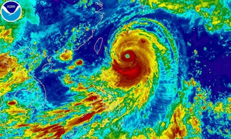
Satellite image by the National Oceanic and Atmospheric Administration (NOAA) showing typhoon Neoguri, the first super-typhoon of 2014 heading towards Japan. Photograph: NOAA/EPA
– Super-typhoon Neoguri approaches Japan’s Okinawa islands (Guardian, July 7, 2014):
Super-typhoon Neoguri is approaching Japan’s Okinawa islands, bringing strong winds and torrential rains.
Gusts of up to 270km per hour (160 miles per hour) are expected to slam into the southernmost subtropical island chain early Tuesday, and may reach mainland Japan by Wednesday. The storm could be one of the worst in decades, the national weather agency said.
The typhoon was located some 600km (370 miles) south of Okinawa’s main island at 3am GMT on Monday, moving north/north-west at 25km (16 miles) per hour.
The meteorological agency forecast that Neoguri, whose name means raccoon in Korean, would dump up to 80mm (three inches) of rain an hour on Okinawa as it pounded the archipelago.
Footage from Okinawa, Japan as typhoon Neoguri approaches
“Please be vigilant, stay inside buildings and avoid working outside and making unnecessary trips,” a meteorological agency official said at a press briefing.The official warned that the storm could mean “record level” winds and could stir up high waves.”Please be ready to evacuate,” the official added.Officials warned residents to stay indoors, while US Kadena Air Force base in Okinawa, the largest US airbase in the Pacific, began evacuating some of its aircraft on Sunday in preparation for the typhoon.
The storm, which could affect an area with a 500km radius, was expected to be downgraded by the time it hit the Japanese mainland.
However, Kyushu region – next to the main island of Honshu where major cities including Tokyo and Osaka are located – was already seeing heavy rains and officials warned over possible floods and landslides.
“I’m calling on the heads of municipalities not to hesitate in issuing evacuation warnings and don’t be afraid of being overcautious,” Keiji Furuya, the state minister in charge of disaster management, told a government meeting.
“I can’t stress enough how dangerous this typhoon may be when it hits Okinawa,” Commander James Hecker of the 18th Wing stationed in Kadena said in a statement posted online.
“This is the most powerful typhoon forecast to hit the island in 15 years; we expect damaging winds to arrive by early Tuesday morning.
“During the typhoon, do not go outside … Anything not tied down, even small items, could become deadly projectiles,” the statement said.
Okinawa is regularly hit by typhoons but islanders were taking no chances with fishermen on Miyako island bringing boats back to port and tying them down with ropes.
“It’s rare that we brace for a typhoon [as early as] July,” a Miyako fisherman said in television footage from public broadcaster NHK.
Footage of fog in Beppu, Oike, 1134km north of Okinawa.