– Hurricane Irma Makes Landfall As Florida Braces For Destruction: Live Feed:
Update 9 (1:10pm): Deputies shot and wounded a burglar and arrested his accomplice at a Florida home as Hurricane Irma blew in.
The Broward Sheriff’s Office said in a news release Sunday that the homeowners in Weston were out of town but saw the burglars remotely inside the house through a home surveillance system. Deputies responded shortly before 3 a.m. and one of the two juvenile males was shot outside the home. He was taken to a local hospital for treatment of non-life threatening injuries. The other person was arrested.
* * *
Update 8 (12:54 pm): Miami’s financial center appears to now be flooding as ocean water enters city streets as part of the storm’s surge.
Brickell flooded with ocean water #Irma @nbc6 @CNN @WPLGLocal10 @wsvn pic.twitter.com/wRzGApcJGs
— SV (@SamVSoares) September 10, 2017
Water ponding in #brickell #irma #miami pic.twitter.com/gMDFgekXSj
— Rosa Flores (@RosaFlores) September 10, 2017
Curious minds in #brickell defying instruction from first responders #irma #miami pic.twitter.com/ruaqmA3kww
— Rosa Flores (@RosaFlores) September 10, 2017
* * *
Update 7 (12:40 pm): Florida sheriff’s deputies rescued a couple who tried to ride out Hurricane Irma on a small sailboat. Christine Weiss of the Martin County Sheriff’s Office said a passer-by noticed the couple was in trouble Sunday. It happened just off Jensen Beach, which is on the Atlantic Coast north of Palm Beach. Video shows a Martin County patrol boat manned by deputies John Howell and James Holloran and Detective Mathew Fritchie pulling up next to the sailboat.
WATCH: Martin County Sheriff’s Office Marine Units rescue two people aboard a sailboat pic.twitter.com/VJ7V6BuDTu
— NBC News (@NBCNews) September 10, 2017
The task of helping the couple onto their boat was precarious as both boats bobbed in choppy water. Deputies then took them to shore. The names of the couple were not released. They were not injured.
* * *
Update 6 (12:25 pm): President Trump has spoken with the governors of Alabama, Georgia, South Carolina and Tennessee as Hurricane Irma moves north. All four states could be affected by the storm, which struck the Florida Keys on Sunday. The White House says Trump spoke with the officials Sunday from the Camp David presidential retreat, where he was spending the weekend. Trump has been in regular contract with Florida Gov. Rick Scott and Sen. Marco Rubio over the past week. Chief of staff John Kelly spoke Sunday with Florida Sen. Bill Nelson.
Trump and Vice President Mike Pence were scheduled to receive an updated Irma briefing on Sunday.
* * *
Update 5 (12:15 pm): Weather Channel Storm Rider and “hurricane hunter”, Juston Drake, was eager to record the strength of Irma; he recorded his attempt in the following striking clip:
@JustonStrmRider tearing it up! pic.twitter.com/VhC97GZJBa
— Simon Brewer (@SimonStormRider) September 10, 2017
* * *
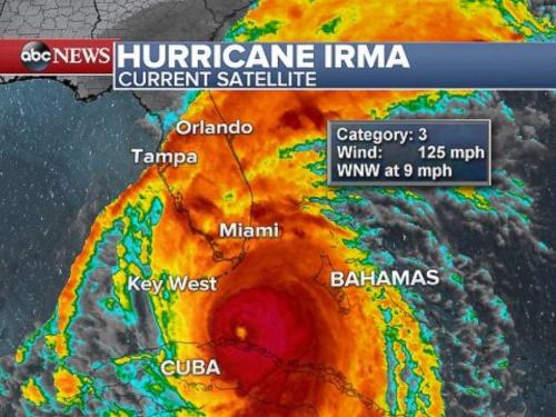
Update 4 (11:17am): According to the latest update from the National Hurricane Center, Category 4 Hurricane Irma is now “headed for the southwest Florida coast” as winds continue to pick up speed in all of South Florida. Irma continues to be armed with 130 mph winds as its large eye passes north of the Keys. Storm surge is forecast for 10 to 15 feet in southwestern Florida.
Hurricane-force winds are continuing throughout southern Florida, including the Keys. The hurricane center warns that winds affecting upper floors of high-rise building will be much stronger than at ground level. The hurricane center also emphasizes that Irma will bring life-threatening wind to much of Florida regardless of the exact track of its center.
* * *
Update 3 (11:10am) : According to the National Weather Service, a crane – one of two-dozen in the city – has collapsed in Miami as strong wind from Hurricane Irma blows in. The weather service’s Miami office tweeted that one of its employees witnessed the crane boom and counterweight collapse in downtown Miami. The employee captured video of the collapse.
Breaking: at least one crane has come down in Downtown Miami. This is next to the Federal prison front of courthouse. @wsvn #HurrcaneIrma pic.twitter.com/sC96QKqM0w
— Brian Entin (@BrianEntin) September 10, 2017
It wasn’t immediately clear if the collapse caused damage or injuries. The cranes have been a concern. Construction sites across Irma’s potential path in Florida were locked down to remove or secure building materials, tools and debris that could be flung by Irma’s winds. But the horizontal arms of the tall tower cranes remained loose despite the potential danger of collapse. According to city officials, it would have taken about two weeks to move the cranes and there wasn’t enough time.
* * *
Update 2 (10:47am): Hurricane Irma’s eye is beginning to move away from the Florida Keys as it continues north with 130 mph (215 kph) winds according to the NHC, which reported that the center of core of Irma is about 25 miles (40 km) northeast of Key West.
Irma is so wide that a gust of 93 mph (150 kph) was measured near Key Largo at the other end of the Florida Keys.
Winds have increased here near Brickell and S.Key Biscayne. Tough conditions now. #Irma #StaySafe pic.twitter.com/97FSx2q1Qn
— Steve Dresner (@stevedresner) September 10, 2017
* * *
Update 1 (10:15am): For the first time ever, a tropical storm warning has been issued for the city of Atlanta. According to the National Weather Service in Peachtree City, Georgia, Sunday was the first time such a warning had been issued for the metro Atlanta area. High wind warnings have been issued in previous storms. According to Bloomberg, the warning means that tropical storm conditions are expected within the next 36 hours. Peak winds were expected to reach 30 to 40 mph (48 to 64 kph) with gusts of up to 55 mph (88 kph). The weather service says storm threats include damage to porches, carports, sheds and unanchored mobile homes. Roads may become impassable due to debris. Power outages could occur.
* * *
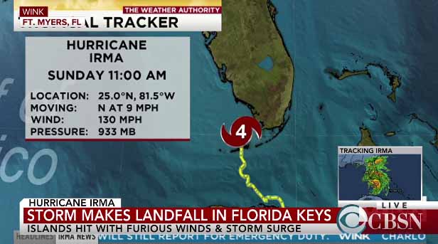
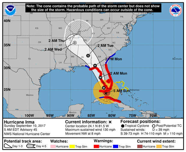
Hurricane Irma, which has strengthened again to Category 4, was delivering destructive winds, torrential rains, and life-threatening storm surge to southern Florida, as the eye of the storm neared the Florida Keys leaving at least one person dead, has just made landfall lower Florida keys.
According to the NHC, the center of Hurricane Irma made landfall at Cudjoe Key in the lower Florida Keys at 9:10 am EDT, with maximum sustained winds of 130mph. A gust of 106 mph (171 kph) was reported on Big Pine Key.
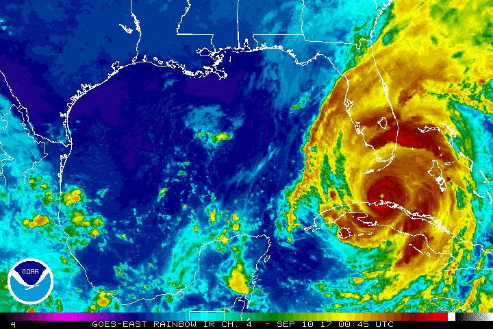
The National Hurricane Center forecasts that the core of Hurricane Irma will likely head directly for the highly populated Tampa-St. Petersburg region after it gets through raking the Keys, but the storm is so massive all of Florida will be feeling the Category 4 hurricane’s fury.
The center of the storm was just off Key West Sunday morning. The latest forecast of Irma’s eye — which still can change — keeps the nearly 400-mile wide (640-kilometer) storm in the water, barely off the coast of southwestern Florida’s Fort Myers and Naples. But that also puts that region in the strongest northeast quadrant of the storm, where storm surge, wind, rain and tornado threats are highest according to Bloomberg.
And a few miles wiggle could bring Irma’s eye — which has measured 30 miles wide (48 kilometers) — inland. The storm is moving slowly, about 8 mph (13 kilometers per hour) so its eye is likely to hit the Tampa region around 2 a.m. Monday, but damaging winds, storm, surge, rain and tornadoes will reach the area long before then.
On Sunday morning, Florida utility officials say more than 1 million customers have lost power as Hurricane Irma hits the state. Florida Power & Light Company said that nearly 1.1 million customers statewide were without power Sunday morning. About 574,000 of those outages were in Miami-Dade County, while there were 360,000 in Broward and nearly 136,000 in Palm Beach County.
The massive storm made landfall in the Florida Keys, and its center was forecast to move up the state’s Gulf Coast. But the effects are being felt far from the center because of Irma’s size.
Irma lashed the area with maximum sustained winds near 130 mph and the U.S. National Hurricane Center said it was expected to remain a powerful storm as it moved through the Florida Keys and near the state’s west coast. Before dawn, gusts were recorded at 94 miles an hour on Smith Shoal Light with sustained winds of 73 miles an hour, while gusts up to 68 mph were observed in Miami, according to the National Hurricane Center.
Good morning from Downtown Miami. Consistent gusts and #Irma is here with 60+mph winds. #StaySafe pic.twitter.com/krDNLoSpRd
— Steve Dresner (@stevedresner) September 10, 2017
Parts of Tennessee were under a tropical storm watch Sunday morning, which could bring be a significant wind event for Alabama, Georgia, southern Tennessee and South Carolina.
The National Weather Service earlier Sunday morning urged everyone in the Florida Keys to “hunker down,” warning, “the worst winds are yet to come.” A tornado watch is also in effect across the area, with two twisters already reported in South Florida.
In Collier County, emergency vehicles were pulled from the roads Sunday morning as heavy wind gusts began blowing in, the county said. A weather station near Fort Pierce reported a four-hour rainfall total of 10.53 inches between midnight and 5 a.m. The rainfall rate along the east coast of Florida was 3 inches per hour.
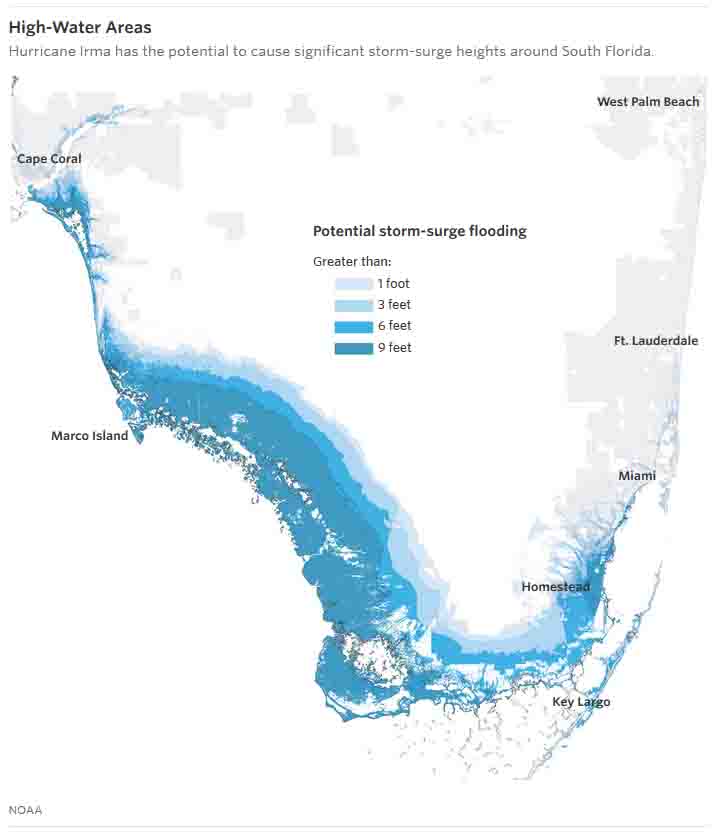
“It’s going to be horrible,” said Florida Gov. Rick Scott on the “Today Show.” He warned that some parts of the state will see storm surges up to 15 feet above ground level. “What is really scary is the storm surge,” Mr. Scott said. “It flushes in and flushes out. That’s going to be difficult to survive.”
Scott said his hometown of Naples on the Gulf Coast could be particularly hard hit. “The waves are already up in the Naples Beach,” Mr. Scott said. “It’s going to be devastating to all those homes on the beaches.”
Collier County, on Florida’s southwest coast, ordered additional evacuations Saturday even as officials were scrambling to find space in jammed shelters before Hurricane Irma brings potentially deadly storm surges.
“Life threatening storm surge is occurring now in the Keys and is expected to begin this morning in Southwest Florida,” Scott warned in an early morning tweet.
Life threatening storm surge is occurring now in the Keys and is expected to begin this morning in Southwest Florida.
— Rick Scott (@FLGovScott) September 10, 2017
Hurricane warnings were in effect for Fernandina Beach southward around the Florida peninsula to Indian Pass, all of the Florida Keys, Lake Okeechobee and Florida Bay.
On Sunday morning, Irma pounded the Miami area with powerful winds and sheets of rain. Wind gusts of about 70 miles an hour hit Miami International Airport and Tamiami Airport, according to the National Weather Service. Officials issued tornado warnings for cities including Hialeah, Pembroke Pines and Hollywood. As the WSJ reports, in a neighborhood west of Miami International Airport, the wind whistled and howled. Trees jerked and shuddered, threatening to split and collapse. Palm trees bent like rubber hoses, and palm fronds littered the ground.
A man in Monroe County, which encompasses Key West, was killed after he lost control of a truck he has driving that carried a generator as winds whipped at tropical-storm strength, according to the Monroe County Sheriff’s Office. The storm left at least 27 people dead across the Caribbean. Hurricane-force winds and torrential rain were already buffeting the Keys, and power was out to the entire island chain.
The U.S. National Hurricane Center said in a public advisory that the center of the storm remained offshore but was going to make landfall soon. The storm was centered about 20 miles east of Key West, and it was moving north-northwest at 8 mph. The storm had maximum sustained winds of 130 mph. The National Weather Service reported wind gusts of 90 mph near its Key West office. After hitting the Florida Keys, Irma was forecast to move up the state’s Gulf Coast later Sunday.
Eye of #Irma should move over the Lower Florida Keys shortly. Eye is 20 miles ESE Key West at 8 am EDT https://t.co/tW4KeGdBFb @NWS @NOAA
— NHC Atlantic Ops (@NHC_Atlantic) September 10, 2017
Florida officials have warned that Irma could be worse than Hurricane Andrew that devastated South Florida in 1992. Andrew, a Category 5 hurricane, killed 61 people in the U.S. and caused nearly $48 billion in economic damage in 2017 dollars, according to the National Oceanic and Atmospheric Administration—the costliest storm in U.S. history until Hurricane Katrina in 2005.
More than 380,000 electricity customers had lost power by early Sunday morning, mostly in Miami-Dade and Broward counties, according to the Florida Division of Emergency Management. The number is expected to grow.
“We are going to lose a lot of power,” Gov. Scott said, cautioning that it will take a while to restore service because crews will have to wait for the storm to pass.
* * *
As of Saturday night, with just hours left until landfall, sometime on Sunday morning, Hurricane Irma is edging ever closer to Florida and has started to batter the state with Hurricane force winds as millions brace for the impact of the most powerful Atlantic storm in a decade.
According to ABC and AP, the National Weather Service measured a 74-mph gust in the Florida Keys on Saturday night, marking the beginning of hurricane-force winds that forecasters say will steadily intensify in the coming hours.
Intense #SouthBeach #SaturdayNight #HurricaneIrma #Curfew now…. 8p-7a @WPLGLocal10 pic.twitter.com/9AE1XDOL38
— Glenna Milberg (@GlennaOn10) September 10, 2017
A tornado watch is in effect across the area, and at least two such twisters have already been reported.
#Tornado in #FortLauderdale #Irma2017 #IrmaFlorida @wsvn @WPLGLocal10 #NBC6 pic.twitter.com/R4Y8Dwj9nN
— Karina Bauza (@SpecialAKB) September 9, 2017
Tornadoes sighted in Broward County, FL. This one captured by @askbiged near Ft. Lauderdale #Irma pic.twitter.com/Dro1ygxOA4
— Mike Seidel (@mikeseidel) September 9, 2017
As of about 10 p.m. Saturday, Irma was 100 miles southeast of Key West with sustained winds of 125 mph. It was moving west, and is expected to turn north and head up the western coast of Florida, making landfall on Sunday.
Hurricane Irma approached Florida, Sept. 9, 2017.
A live feed tracking the hurricane is shown below, courtesy of ABC:
WATCH LIVE on @Twitter: Tracking Hurricane #Irma as it nears Florida. https://t.co/edbKM7HXVW https://t.co/nM5ICooi3W
— ABC News (@ABC) September 10, 2017
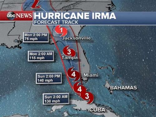
According to Hurricane Tracker, the peak forecast wind gust city-by-city is as follows:
- Miami: 74 mph (Sun. Morning)
- Key West: 144 mph (Sun. Morning)
- Naples: 141 mph (Sun. Morning)#Irma
- Tampa: 139 mph (Sun. Night)
- Orlando: 74 mph (Sun. Night)
- Fort Myers: 134 mph (Sun. Afternoon)
Peak forecast wind gust city-by-city:
Tampa: 139 mph (Sun. Night)
Orlando: 74 mph (Sun. Night)
Fort Myers: 134 mph (Sun. Afternoon)#Irma pic.twitter.com/9mxfEBqUep— HurricaneTracker App (@hurrtrackerapp) September 10, 2017
The NHC is expecting a storm surge anywhere between 6 and 12 feet.
.@NHC_Atlantic is forecasting 6 to 12 feet of storm surge from #Irma pic.twitter.com/plqh9cosO0
— NWS (@NWS) September 8, 2017
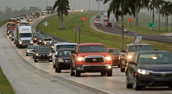
The storm, which was downgraded to Category 3 after making landfall as a rare Category 5 hurricane in Cuba overnight but is expected to strengthen once more before again making landfall in Florida, has sent 75,000 people into shelters in Florida. More than six million people, or nearly a third of Florida’s population, have been warned to evacuate its path.
The National Hurricane Center on Friday cautioned that Irma’s winds would likely be strong enough to uproot trees, bring down power poles and rip off the roofs and some exterior walls of well-built frame homes. “Obviously Hurricane Irma continues to be a threat that is going to devastate the United States,” Brock Long, administrator of the Federal Emergency Management Agency (FEMA), said at a press conference Friday morning. “We’re going to have a couple rough days.”
Several counties and cities in south Florida have issued a curfew as the storm draws near. Broward County set a curfew for 4 p.m. Saturday and said no unauthorized vehicles will be allowed on the roads. Charlotte County and the City of Miami Beach will enter one later tonight. Palm Beach County has issued a curfew to prevent looting and other criminal activity as the storm approaches, according to a press release. The curfew goes into effect Saturday at 3 p.m. It is unclear when it will be lifted.
Some 10,000 flights have been cancelled in anticipation of Irma, about 7,000 of them in Florida alone.
Florida Gov. Rick Scott called the storm unprecedented. “This is a life-threatening situation,” Florida Gov. Rick Scott said Saturday. “Our state has never seen anything like it.” The governor stressed the dangers of what he called a “deadly, deadly, deadly storm surge.”
President Trump tweeted a video from a Cabinet meeting Saturday, telling people to “get out of” Irma’s way. “Property is replaceable but lives are not. and safety has to come first. Don’t worry about it, get out of its way,” Trump said.
Meteorologists from ABC News are forecasting storm surges of 10 feet in Tampa and Sarasota, and 10 to 15 feet from Fort Myers to Naples. Somewhat lower storm surges of 3 to 6 feet may occur from Miami to Key Largo. Winds were already picking up in Florida early Saturday, with gusts between 40 and 60 mph, as the following clip shows:
Huge gusts here Downtown Miami and @mikeseidel at his best! #Irma #StaySafe pic.twitter.com/wyvta8TRnW
— Steve Dresner (@stevedresner) September 10, 2017
Hurricane-force winds with gusts over 115 mph are possible in the Keys by daybreak Sunday. More tornadoes are also likely and a tornado watch was issued Saturday for southern Florida.
According to ABC, Florida state residents should anticipate days-long power outages, FEMA said. Ahead of Irma’s arrival in the Sunshine State, the last flights departed Friday night from Miami International Airport and Fort Lauderdale-Hollywood International Airport. Miami’s airport officially remains open, while Fort Lauderdale’s airport is closed for Saturday and Sunday. Meanwhile, many ATM machines across southwest Florida were out of cash by late Friday night after people stocked up in case Hurricane Irma causes power outages that make debit and credit card transactions impossible, the Associated Press reported.
Meanwhile, as millions evacuate, Germain Arena, a large shelter between Naples and Fort Myers along Florida’s west coast, is already at capacity Saturday as hundreds of people were in line waiting to get in. Miami-Dade County Mayor Carlos A. Giménez said Saturday morning about 25,000 residents are sheltered in Miami-Dade alone, a number he called “unprecedented in our history.”
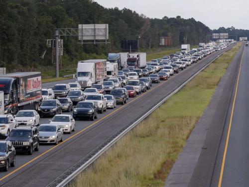
Traffic streaming out of Florida creeps along northbound Interstate 75 after a
vehicle accident in Lake Park, Ga., Sept. 6, 2017.
“We must remain vigilant,” Giménez said. “The storm will still strengthen … and we will be impacted.”
* * *
PayPal: Donate in USD
PayPal: Donate in EUR
PayPal: Donate in GBP