USGS: Magma Rising In Mount St. Helens Volcano

Magma rising in Mount St. Helens volcano, says USGS (Ice Age Now, May 15, 2014):

No sign of impending eruption – Crater Glacier growing rapidly


“The magma reservoir beneath Mount St. Helens has been slowly re-pressurizing since 2008,” the U.S. Geological Survey said in a statement on April 30, 2014. “It is likely that re-pressurization is caused by (the) arrival of a small amount of additional magma 4 to 8 km (2.5 to 5 miles) beneath the surface.”

The USGS said this is to be expected with an active volcano and does not indicate “the volcano is likely to erupt anytime soon.”

When Mount St. Helens, a volcano in Washington State, erupted on May 18, 1980, it crushed entire forests and altered local river systems.


What this article doesn’t mention


What this article doesn’t mention, is that that eruption also melted the glaciers at the top of the mountain sending a deadly slurry of ice, mud, huge trees, bulldozers, and anything else in the way, in a mad rush down the Toutle River.

At the time of the 1980 eruption, 11 named glaciers radiated down the flanks of the volcano along with two small unnamed glaciers and numerous perennial snowfields, according to the USGS. The largest glaciers extended about 2.5 (1.5 mi) from the ice-filled summit crater. The cataclysmic landslide and eruption removed about 70% of the glacier mass.
Read moreUSGS: Magma Rising In Mount St. Helens Volcano

Breaking News: Idaho And Utah On Alert For Yellowstone Eruption – USGS Suppressing Supervolcano Activity At Yellowstone Under White House Orders’ (Videos)

H/t reader squodgy:

“Magma movement under NE USA is becoming a concern, but in true fashion, like with Fukushime, there is a news clampdown.”

Flashback:

Outgoing DHS Secretary Janet Napolitano Warns of ‘Serious’ Cyber Attack, Unprecedented Natural Disaster (ABC News, Aug 27, 2013):

The outgoing Homeland Security Secretary has a warning for her successor: A massive and “serious” cyber attack on the U.S. homeland is coming, and a natural disaster — the likes of which the nation has never seen — is also likely on its way.


ALERT: IDAHO AND UTAH ON ALERT FOR YELLOWSTONE ERUPTION


Added: Apr 16, 2014

Description:

They know the recent earthquake are in fact from lava/magma movement!
http://www.bhs.idaho.gov/Pages/Plans/…

http://earthquaketrack.com/r/southern…

http://www.isthisthingon.org/Yellowst…

http://www.reuters.com/article/2014/0…

ALERT: USGS Suppressing Supervolcano Activity At Yellowstone Under White House Orders’


Added: Mar 4, 2014

Description:

http://intellihub.com/unnamed-source-…

Check ou the earthquakes yourself
http://quake.utah.edu/helicorder/yell…

http://www.seis.utah.edu/req2webdir/r…

Offshore 6.9 Magnitude Earthquake Shakes Northern California

Offshore 6.9 magnitude earthquake shakes Northern California (CNN, March 10, 2014):

An offshore 6.9 magnitude earthquake and aftershocks shook the coast of Northern California and parts of Oregon on Sunday night, the U.S. Geological Survey said. No major damage or injuries were immediately reported.

The main quake, centered in the Pacific Ocean about 50 miles west of Eureka, California, happened at 10:18 p.m. PT, the USGS said. The depth was about 10 miles.

Read moreOffshore 6.9 Magnitude Earthquake Shakes Northern California

Major 7.8 Earthquake Strikes Iran, ‘Hundreds Of Deaths’ Expected

Major 7.8 Earthquake Strikes Iran Leaves “Hundreds Dead”; Follows 6.1 Quake From Week Ago (ZeroHedge, April 16, 2013):

It was only a week ago that Iran was shaken by a major 6.1 earthquake, striking just 100 km away from the Busher nuclear power plant: a location so “opportune” some, so inclined, saw in this phenomenon anoter demonstration of the HAARP’s capabilities. Those same people will then hardly be surprised to learn that moments ago the entire middle east, from Dubai to Delhi, shook in the aftermath of yet another massive earthquake, this time measuring 7.8 on the Richter scale, which once again was located as the USGS reports, some 86 km East South East of Khash, Iran. According to preliminary reports, the USGS says there is possibility of heavy damage in area of epicenter, and an estimated 359,000 people felt very strong to severe shaking. USGS also estimates that 16K may have felt ‘severe’ shaking, 343K ‘very strong’ shaking, 1.7M ‘strong’ shaking; 1.1M ‘moderate’ shaking. An Iranian official was promptly on the tape saying hundreds of dead expected from quake in southeast of country, even as the Russian company that built the Busher NPP saying there was no damage from the quake. How much more shaking can either the existing Iranian nuclear power plant, or the much maligned nuclear facility in Fordow, sustain before they go off in a big glowing mushroom cloud: that is the question.

From Al Jazeera:

A magnitude 7.8 earthquake has struck southeastern Iran near the border with Pakistan, reportedly killing at least 40 people with casualties expected to rise.

The US Geological Survey reported on Tuesday that the epicentre of the quake was 86km southeast of Khash, Iran.

The Iranian news agency FARS is reporting 40 initial casualties.

An Iranian government official said on Tuesday he expected hundreds of deaths from the earthquake.

“It was the biggest earthquake in Iran in 40 years and we are expecting hundreds of dead,” said the official, who spoke on condition of anonymity.

Read moreMajor 7.8 Earthquake Strikes Iran, ‘Hundreds Of Deaths’ Expected

More Than 70 Earthquakes Hit California Border, Buildings Damaged

More than 70 earthquakes hit California border; buildings damaged (Los Angeles Times, Aug 26, 2012):

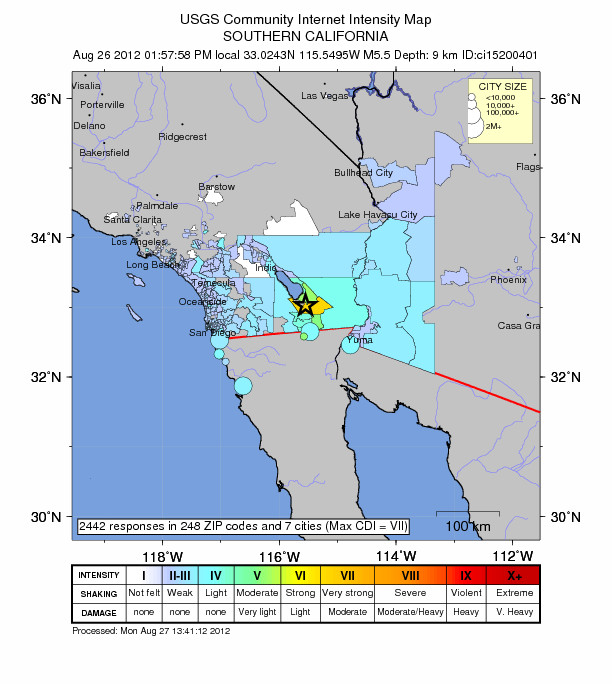
More than 70 earthquakes hit Imperial County on Sunday — including several that registered stronger than magnitude 4.0. The strongest measured 5.4.

The USGS’s “Do You Feel It” system shows the quakes were felt as far away as San Diego, Temecula and San Clemente. The 5.3 quake was felt in Moreno Valley, Indio, National City and Palm Desert, and in Yuma, Ariz., and Mexico.

A handful of buildings in downtown Brawley had minor damage after an earthquake swarm rattled the area Sunday, officials said. Most of the quakes occurred in and around that California town.

Read moreMore Than 70 Earthquakes Hit California Border, Buildings Damaged

Human-Made Earthquakes Reported In Central U.S (Reuters)

Human-made earthquakes reported in central U.S (Reuters, Apr 17, 2012):

The number of earthquakes in the central United States rose “spectacularly” near where oil and gas drillers disposed of wastewater underground, a process that may have caused geologic faults to slip, U.S. government geologists report.

The average number of earthquakes of magnitude 3 or greater in the U.S. midcontinent – an area that includes Arkansas, Colorado, Oklahoma, New Mexico and Texas – increased to six times the 20th century average last year, scientists at the U.S. Geological Survey said in an abstract of their research.

Read moreHuman-Made Earthquakes Reported In Central U.S (Reuters)

Small Tsunami Hits Japan After Strong 6.9 Magnitude Earthquake

See also:

Fallout Is Increasing In Fukushima Again


Small tsunami hits Japan after 6.9 quake (AFP, Mar 15, 2012):

A small tsunami hit Japan’s northeastern coastline on Wednesday, officials said, after a strong earthquake rocked the region almost exactly a year on from the country’s worst post-war natural disaster.

A 6.9-magnitude quake struck 26.6 kilometres (16 miles) below the seabed off the northern island of Hokkaido in the Pacific at 6:08 pm local time (0908 GMT), the US Geological Survey said.

Read moreSmall Tsunami Hits Japan After Strong 6.9 Magnitude Earthquake

USGS Paper: “Wet Deposition of Fission-Product Isotopes to North America from the Fukushima Dai-ichi Incident, March 2011”

USGS Paper: “Wet Deposition of Fission-Product Isotopes to North America from the Fukushima Dai-ichi Incident, March 2011” (EX-SKF, Feb. 24, 2012):

The paper by Wetherbee, Gregory A. et al was published online on February 22, 2012 ahead of the print, on Environmental Science and Technology.

Abstract, from Environmental Science and Technology (emphasis is mine):

Using the infrastructure of the National Atmospheric Deposition Program (NADP), numerous measurements of radionuclide wet deposition over North America were made for 167 NADP sites before and after the Fukushima Dai-ichi Nuclear Power Station incident of March 12, 2011. For the period from March 8 through April 5, 2011, wet-only precipitation samples were collected by NADP and analyzed for fission-product isotopes within whole-water and filterable solid samples by the United States Geological Survey using gamma spectrometry.

Variable amounts of 131I, 134Cs, or 137Cs were measured at approximately 21% of sampled NADP sites distributed widely across the contiguous United States and Alaska. Calculated 1- to 2-week individual radionuclide deposition fluxes ranged from 0.47 to 5100 Becquerels per square meter during the sampling period. Wet deposition activity was small compared to measured activity already present in U.S. soil. NADP networks responded to this complex disaster, and provided scientifically valid measurements that are comparable and complementary to other networks in North America and Europe.

The map above the abstract at Environmental Science and Technology indicates cesium-137 deposition between 0.8 to 240 becquerels/square meter. But without seeing the paper I have no idea how the numbers on the map are related to the numbers in the abstract. (My guess is that the numbers in the abstract, particularly the high number, include iodine-131.)

Read moreUSGS Paper: “Wet Deposition of Fission-Product Isotopes to North America from the Fukushima Dai-ichi Incident, March 2011”

US Government Confirms Link Between Earthquakes And Fracking

Flashback:

Fracking Hell: Toxic And Radioactive Waste – The Untold Story


U.S. Government Confirms Link Between Earthquakes and Hydraulic Fracturing (ZeroHedge, Nov. 9, 2011):

On 5 November an earthquake measuring 5.6 rattled Oklahoma and was felt as far away as Illinois.

Until two years ago Oklahoma typically had about 50 earthquakes a year, but in 2010, 1,047 quakes shook the state.

Why?

In Lincoln County, where most of this past weekend’s seismic incidents were centered, there are 181 injection wells, according to Matt Skinner, an official from the Oklahoma Corporation Commission, the agency which oversees oil and gas production in the state.

Cause and effect?

Read moreUS Government Confirms Link Between Earthquakes And Fracking

5.0 Gulf Of Aden Earthquake: Andromeda Council Sonic Beam Destroys Reptilian Base (Video)

For your information.

This underground base, as mentioned in the article below, has supposedly also been destroyed:

Former Governor Jesse Ventura – Secret Underground 2012 Base at Denver Airport

See also:

RT: Russians to Build 5000 Bomb Shelters in Moscow by 2012

Deep Underground Military Bases (D.U.M.B.S.) – US Has Been Building Large Scale Underground Cities – For 2012?

I am just posting this because WW III is/has been on the elitist agenda, starting in the middle east and then spreading from there throughout the entire world.

If  all these elitist bunkers get destroyed, then WW III will be (most probably) canceled and their NEW WORLD ORDER is in big trouble.

I could go more into detail why I have finally decided to post this ‘TOTALLY CRAZY’ material, but right now I  believe/think the time has not yet come to discuss that.


By Alfred Lambremont Webre, JD, MEd

ED. NOTE: CAVEAT LECTOR – The opinions expressed in this article by interviewees are solely those of the interviewees and do not necessarily reflect the opinions of this reporter or Exopolitics.com. Thank you.


YouTube Added: 31.10.2011

5.0 Gulf of Aden quake: Andromeda Council sonic beam destroys reptilian base (Examiner, Nov. 1, 2011):

Confirmation – Destruction of Reptilian undersea base

In an exclusive Oct. 31, 2011 ExopoliticsTV interview, the human representative of the Andromeda Council confirmed that a 5.0 earthquake reported by the U.S. Geological Survey (U.S.G.S.) to have occurred in the Gulf of Aden at 1:22 am on October 31, 2011 was in fact an effect of a sonic beam weapons attack by the Procyon star system (members of the Andromeda Council) on a Draco & Reptilian undersea base located at the same coordinates as the epicenter of the Gulf of Aden earthquake. (See FIG A for U.S.G.S. map setting out the exact epicenter of the Gulf of Aden earthquake).

In an October 31, 2011 statement, Tolec, the human representative of the Andromeda Council stated, “Yes, I was able to confirm this event with the commander of the primary biosphere where many of the Andromeda Council meetings are held.  This was a strike by the Procyon people.  They’re just doing their job as promised.  This base in now completely collapsed & destroyed.”

Read more5.0 Gulf Of Aden Earthquake: Andromeda Council Sonic Beam Destroys Reptilian Base (Video)

Lethal Injection: The Story Of Vaccination (Documentary)


YouTube Added: Sep 30, 2011

The definitive look into the history of vaccination. From cancer, to autism, to the purposeful sterilization of innocent people around the globe, find out why all of these things are perfectly legal according to U.S. CODE – why the government considers you no different than cattle in their own law.

More information on vaccinations:

Gov. Rick Perry lies again about Texas Gardasil scandal, claims woman he met after signing executive order lobbied him to pass it

GMO Gardasil DNA Contamination: EMA Steps Up To The Plate, FDA Drops The Ball

Outrage: 100% Human Papillomavirus (HPV) DNA Contamination In GMO Gardasil Vaccine Reported To FDA

3 Girls Dead, Others Hospitalized After Gardasil HPV Vaccine

100 Compiled Studies on Vaccine Dangers

Read moreLethal Injection: The Story Of Vaccination (Documentary)

Magnitude 6.0 Earthquake EAST COAST USA (Downgraded To A 5.9) (08/23/2011)


YouTube

http://earthquake.usgs.gov/earthquakes/recenteqsus/Quakes/usc0005ild.php This event has been reviewed by a seismologist.

Magnitude 5.9
Date-Time Tuesday, August 23, 2011 at 17:51:03 UTC Tuesday, August 23, 2011 at 01:51:03 PM at epicenter Time of Earthquake in other Time Zones

Location 37.975°N, 77.969°W
Depth 1 km (~0.6 mile) (poorly constrained)
Region VIRGINIA
Distances 45 km (27 miles) E of Charlottesville, Virginia
55 km (34 miles) SW of Fredericksburg, Virginia
64 km (39 miles) NW of RICHMOND, Virginia
82 km (50 miles) NNE of Farmville, Virginia

Global Earthquake And Volcano Update And Overview: UPTICK Continues! At Least One 6.0 Magnitude Quake Per Day (Video – 08/06/2011)


YouTube

At least one 6.0 magnitude quake per day… volcanoes.. Mt. Etna, Cleveland, Pu’u O’o (hawaii), Stromboli volcano, Popocatépetl Mexico, Sakurajima Japan all erupting this past week !

USGS statistics say average is one every 3-5 days… that means a 33% increase (approx).

Links below:

Read moreGlobal Earthquake And Volcano Update And Overview: UPTICK Continues! At Least One 6.0 Magnitude Quake Per Day (Video – 08/06/2011)

Magnitude 6.2 Earthquake Hits Japan, 6.4 Hit Saturday And A Magnitude 6.2 Quake Hits Papua New Guinea (Video)

Before:

Magnitude 6.4 Earthquake In Japan, Near East Coast Of Honshu (07/23/2011)


YouTube

6.2-magnitude quake hits Japan’s Fukushima Prefecture (Xinhua):

TOKYO, July 25 (Xinhua) — An earthquake measuring 6.2 on the Richter scale jolted Japan’s northeastern Fukushima Prefecture and its vicinity on early Monday Morning, said the Japan Meteorological Agency.

The focus of the quake, which occurred at 03:51 a.m. local time was located some 40 km under the sea off Fukushima, said the agency.

There were no immediate reports of casualties or damage to properties, and no tsunami warning was issued. Tremors were felt in Tokyo, about 240 kilometers away from the prefecture.

Strong earthquake jolts Japan (News24):

New York – The US Geological Survey is reporting that another strong earthquake has jolted northeastern Japan, the same region devastated by March’s massive quake and tsunami. There are no immediate reports of injuries or damage, and no tsunami warning is in effect.

The USGS says the magnitude 6.2-quake struck at 03:51 on Monday and was centred at a depth of 35.6km in the Pacific Ocean, 94km east of Fukushima prefecture. The epicentre is 282km northeast of Tokyo.

On Saturday afternoon, a magnitude-6.4 quake struck in the same area off the east coast of Honshu.

Magnitude 6.4 Earthquake In Japan, Near East Coast Of Honshu (07/23/2011)


YouTube Added: 23.07.2011

There may be a possible tsunami warning issued with this..

link to my latest earthquake update video:

http://www.youtube.com/watch?v=85gjD48Rrpk&feature=channel_video_title

http://earthquake.usgs.gov/earthquakes/recenteqsww/Quakes/usc000531r.php

This event has been reviewed by a seismologist.
Magnitude 6.4
Date-Time Saturday, July 23, 2011 at 04:34:24 UTC
Saturday, July 23, 2011 at 01:34:24 PM at epicenter
Time of Earthquake in other Time Zones

Location 38.932°N, 141.907°E
Depth 38.6 km (24.0 miles)
Region NEAR THE EAST COAST OF HONSHU, JAPAN
Distances 112 km (69 miles) SE of Morioka, Honshu, Japan
125 km (77 miles) NE of Sendai, Honshu, Japan
165 km (102 miles) ENE of Yamagata, Honshu, Japan
414 km (257 miles) NNE of TOKYO, Japan

Magnitude 5.6 Earthquake Near Fukushima Nuke Plant

5.6 quake rattles Japan near Fukushima site (AP, July 07, 2011):

NEW YORK — An earthquake registering 5.6 shook the Pacific off Honshu, Japan, the U.S. Geological Survey said Thursday. That is the area of northeast Japan ravaged by a March 11 quake and tsunami that knocked out power at the Fukushima nuclear plant.

No immediate damage or casualties were reported from the quake that struck at 3:35 a.m. Friday (1835 GMT Thursday), the USGS said. No tsunami watch was immediately issued.

The epicenter of the quake was some 51 miles (83 kilometers) southeast of Fukushima, in Honshu, Japan, the USGS said. The quake was centered some 28 miles (45 kilometers deep, the agency said.

Read moreMagnitude 5.6 Earthquake Near Fukushima Nuke Plant

Worldwide Global Earthquake And Volcano Update And Overview (05/09/2011) – Pressure Buildup On The North American Plate, Yellowstone & Pacific Northwest Earthquake Activity & Magma Movement


Pressure is building on the north American plate beyond the rocky mountain continental divide. As far north as the Cascadia range in the Pacific Northwest, south east to Yellowstone, then further south east to Georgia, up north to Montreal / New York …

The threat of a new madrid earthquake , in my opinion, goes up ANOTHER notch, with the signs of more activity in the north east, extending along the faults down to Arkansas.

Read moreWorldwide Global Earthquake And Volcano Update And Overview (05/09/2011) – Pressure Buildup On The North American Plate, Yellowstone & Pacific Northwest Earthquake Activity & Magma Movement

Global Earthquake And Volcano Overview – New Madrid Strangely SILENT (05/03/2011)

See also:

THEY DID IT! James Bond ‘A View To A Kill’ Scenario Comes True: US Government Floods The New Madrid Fault!


Added: 03.05.2011

Areas of specific concern for a greater than 5 magnitude earthquake in the next two weeks are:

Read moreGlobal Earthquake And Volcano Overview – New Madrid Strangely SILENT (05/03/2011)

New Madrid Fault System: Mulptile Charts Show Movement – USGS Censors Data Again

It appears we have another “yellowstone situation”… a couple months ago.. the USGS decided they were going to just NOT SHOW earthquakes on the “real time” map or feeds….

They literally censored a whole earthquake swarm from yellowstone just a month and a half ago..

Now again.. we see them at work.. but this time.. it is the midwest USA. Clearly .. quakes are on the charts.. but if you go over to USGS .. nothing on the list or the maps!!!!

Read moreNew Madrid Fault System: Mulptile Charts Show Movement – USGS Censors Data Again

Study: 100 Percent of Fish in US Streams Contaminated with Mercury

(NaturalNews) In a new study conducted by the U.S. Geological Survey (USGS), every single fish tested from 291 freshwater streams across the United States was found to be contaminated with mercury.

“This study shows just how widespread mercury pollution has become in our air, watersheds and many of our fish in freshwater streams,” said Interior Secretary Ken Salazar.

Mercury is a potent neurotoxin that builds up in the food chain at ever higher concentrations in predators such as large fish and humans. It is especially damaging to the developing nervous systems of fetuses and children, but can have severe effects on adults, as well. The pollutant enters the environment almost wholly as atmospheric emissions from industrial processes, primarily the burning of coal for electricity. It then spreads across the plant and settles back to the surface, eventually concentrating in rivers, lakes and oceans, where it enters the aquatic food chain.

The number one cause of human mercury poisoning in the United States is the consumption of fish and shellfish.

Read moreStudy: 100 Percent of Fish in US Streams Contaminated with Mercury