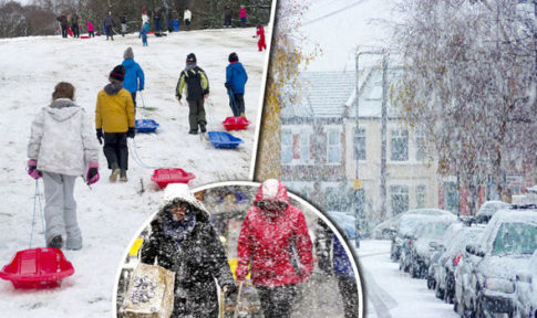
Forecasters have warned of heavy snow this winter as temperatures plunge to arctic levels
– UK set for HEAVIEST SNOWFALL in years: Long-range forecast warns of Winter 2016 BIG FREEZE:
BRITAIN is facing the heaviest snowfalls in years this winter as the country’s first icy blast arrives in SIX WEEKS unleashing FOUR MONTHS of heavy snow and sub-zero temperatures, forecasters have announced.
Thermometers are about to plunge amid predictions of crippling snowstorms and major whiteouts lasting into February.
Experts warn to expect a very “exciting” December even hinting at the possibility of a White Christmas this year.
After several mild and wet winters 2016 will buck the trend with the UK now facing the coldest and snowiest for at least six years.
Britons are warned not to be lulled into a false sense of security by the unusually hot September weather and the mild autumn so far.
A dramatic swing towards colder conditions will see temperatures plummet across the country as freezing air sweeps in from the Polar regions.
In stark contrast to last year, which was one of the mildest winter’s on record, extreme cold is forecast to set in at the start of November.
People in the north have been warned to batten down the hatches for “potent” winter blasts, blizzards and heavy snow across the country.
In another twist of misery any mild spells will be ravaged by storms unleashing torrential downpours, gales and flooding.
James Madden, forecaster for Exacta Weather, said the first bitter blast will hit the north in as early as November.
He said the next four months could be plagued by heavy and persistent snow broken up by storms and heavy rain.
He said: “Despite the much warmer than average but unsettled summer and the warm start to autumn, people should not be lulled into a false sense of security.
“Throughout this winter we fully expect some quite potent wintry blasts from as early as November for the northern half of the country, and even the southern half of the country can expect some prolonged wintry weather at times.
“This does not dispel some large temperature swings to milder and potentially stormy weather conditions throughout this winter period, but we do expect less stormy weather conditions throughout this winter and in comparison to the last few winter periods.”
The bitter forecast comes amid predictions subtle changes in atmospheric pressure will open the floodgates to freezing air from the Arctic through the season.
A strong negative Arctic and North Atlantic Oscillations forecast to play a major role in influencing Britain’s weather this winter.
In its negative phase, the North Atlantic Oscillation (NAO) sees atmospheric pressure drop around Bermuda and rise over Iceland.
This creates a reduced pressure gradient between the two regions and a weakening of the prevailing westerly winds which usually steer mild, stormy conditions into the UK from the Atlantic.
During this negative phase, northern Europe, including Britain, is open to winds coming from further north and winter is usually colder as a result.
The same is true of the Arctic Oscillation (AO) which in its cold negative phase weakens westerly winds high up allowing cold air from the Polar region to sink into northern Europe.
Current forecasts show both the NAO and the AO switching to a negative phase in the coming months.
Mr Madden explained: “Our forecasting analysis and the stage of solar activity we are at also favour a more negative trending Arctic Oscillation (AO) and North Atlantic (NAO) this winter.
“An early indication of things going to plan should be visible in the well above-normal snow cover in Eurasia this autumn.
“These factors will also contribute to a blocking pattern that will allow easterly and north easterly winds to dominate with numerous snow events throughout December and January.”
Britain has been beset by weather anomalies through the past 12 months with last winter the third warmest on record and last month delivering the hottest September day for 105 years.
The start of summer was exceptionally cold while heavy downpours towards the middle of the season threatened to tumble records for rain.
According to independent meteorologist Matthew Hugo this winter is shaping up to be “very different” from last year.
This is partly due to last year’s very strong El Nino Pacific Ocean warming now entering a neutral phase, he said.
The event, which has major repercussions on the weather around the globe – was the most powerful on record.
Temperatures around the east coast of South America have dropped to normal values although there are signs El Nino’s cooling counterpart La Nina, which is linked to colder winters in northern Europe, may come into force this year.
Mr Hugo said: “After the very strong El Nino of last winter we have now progressed towards near neutral conditions and with an on-going trend towards La Nina.
“Some of the main forecast models highlight that through the winter period a weak La Nina is expected to be in evidence.
“Clearly this will be in complete contrast to the ‘strong’ El Nino of last winter.”
He said this winter may also come under the influence of the Quasi-biennial Oscillation (QBO) – a change in wind directions in the stratosphere above the Equator.
The cycle sees strong westerly winds which blow in a continuous circuit around the Earth weaken and even reverse to easterlies.
This affects winds lower down with the change associated with a switch from either mild and stormy (westerly phase) or cold (easterly phase) winters in northern Europe.
Mr Hugo said: “The QBO phase this winter is expected to be opposite of last year with an easterly phase expected.
“Without going into the details of the QBO too much, essentially think of the QBO phase as a system that can facilitate the development of a more potent northern hemisphere polar vortex.
H/t reader kevin a.
* * *
PayPal: Donate in USD
PayPal: Donate in EUR
PayPal: Donate in GBP
Then the warm weather indicates a heavy change in weather conditions? It is possible using the stockmarket as a metaohor, there a parabolic rise is the message for a downturn. Hopefully it will happen.