– The “Historic” Winter Blizard Was Just Upgraded To A “Potentially Epic Winter Blockbuster”:
Yesterday some readers were offended when we dubbed the upcoming winter storm set to slam the Northeastern United States and impact up to 50 million people, in roughly 48 hours as “potentially historic” – a phrase created not by us, but by the WaPo’s meteorologists.
Still, what’s the big deal, the purists will say, pointing out that snow in January is not exactly a shocking event. We fully agree, however we would like to remind readers that “snow in the winter”, especially when coupled with, gasp, cold weather, is precisely what the US Bureau of Economic Analysis used as justification ot arbitrarily push Q1 GDP in both 2014 and 2015 higher by nearly 1% as a result of “incremental” seasonal adjustments after the fact, the explanation being that the cold weather and the snow resulting from a handful of blizards ended up crushing the US economy.
Of course, as we explained on numerous occasions in the past, the dramatic slowdown of the US economy in 2014 and 2015 had nothing to do with the weather and everything to do with the bursting of the Chinese housing bubble first in late 2013 and then of its shadow banking bubble in late 2014, two events whose reveberation around the globe slammed the US economy into an acute, if brief, contraction.
As such the only reason why any weather events are notable, is to observe whether the BEA once again uses the weather as a scapegoat for the third year in a row, to justify a collapse in GDP to zero, or negative even though just one month ago retailers were complaining about their lack of revenue growth and collapse in profits as a result of warm weather.
Which brings us back to the upcoming winter storm where the hyperbole factor just went up a notch, this time courtesy the Weather Undereground’s Bob Henson, who has decided that merely “historic” is too cut and dry, and has instead dubbed the imminent climatic phenomenon not only “potentially epic” but a “winter blockbuster” to boot.
Which is just the soundbite cover the US BEA needs to whip out triple seasonal adjustments and “calculate” that Q1 GDP did not really contract but when you melt the snow on a pro forma, “non-GAAP” basis, GDP likely grew by some $50 billion more.
Here is what, according to yet another weather forecaster, is in store for the Northeast courtesy of The Wunderground:
Mid-Atlantic Braces for Potentially Epic Blizzard
For an event still several days out, computer models were in remarkable agreement late Tuesday on what could be one of the greatest snowstorms in decades for the region around Washington, D.C. It’s difficult to convey what the models are projecting without appearing to sensationalize the event, but here goes: there is every indication that snow totals on the order of two feet are quite possible across parts of the greater D.C./Baltimore area, with the potential for almost as much in Philadelphia and perhaps a foot toward New York City. Anything over 20” at Washington National Airport would be the greatest snowfall for D.C.’s official reporting station in almost a century (see below).
Although it’s too soon to get too precise about exact amounts and locations, confidence is uncommonly high for a high-impact event in the mid-Atlantic. The 0Z Wednesday run of the GFS doubled down on the prognosis, with projected snowfall amounts exceeding 30” within commuting distance of the district (see Figure 1). As a group, the ensemble members with this GFS run weren’t quite as bullish, but as noted by Capital Weather Gang, the ensemble average still projects a widespread 20” or more over much of the D.C. area. At this writing, the 0Z operational run of the ECMWF model was just coming in, and it appeared just as compelling as the GFS output below in terms of a potential record-breaking storm for the D.C. area.
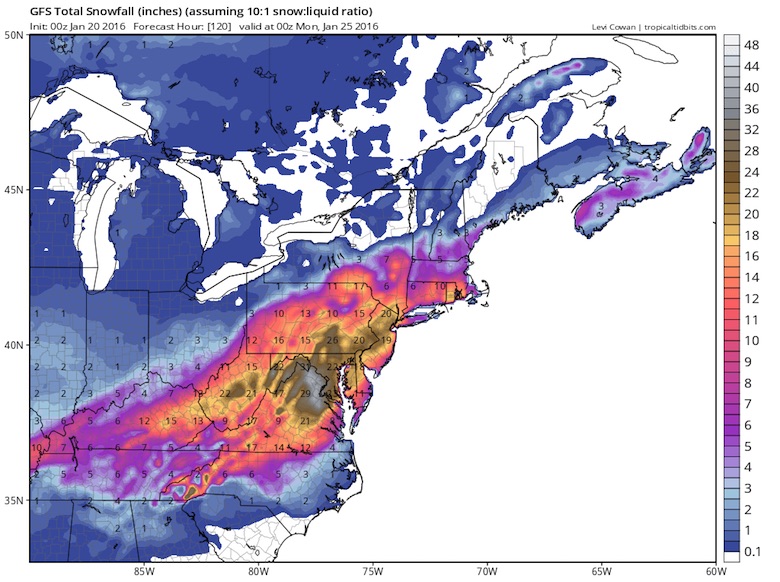
Figure 1. Snowfall totals generated by the 0Z Wednesday operational run of the GFS model for the period from 0Z Wednesday (7:00 pm EST Tuesday) to 0Z Monday (7:00 pm EST Sunday). Amounts are calculated by assuming a 10:1 ratio of snow to melted water; the actual ratio can vary significantly from place to place within a storm. Keep in mind that forecasters rely on the output from a wide range of models and their trends over time before making specific snowfall predictions. Image credit: Levi Cowan, tropicaltidbits.com.
The making of a winter blockbuster
The impetus for the storm is an upper-level impulse that was moving into the Pacific Northwest late Tuesday. The jet-stream energy will sweep across the mid-South on Thursday into Friday, helping produce a quick shot of snow and ice for parts of Arkansas, Kentucky, and Tennessee. Snow could begin as soon as midday Friday ahead of this impulse over the D.C. area. Then, as the jet-stream energy carves out a powerhouse upper low, a surface cyclone should intensify on Saturday off the Virginia coast–a prime location for big mid-Atlantic snowstorms. In classic fashion, the low-level cyclone will funnel warm, moist air from the tropical Atlantic into the region, with the air mass cooling and generating snow as it rises.
The storm’s expected evolution is “textbook,” said NOAA’s Paul Kocin in an NWS forecast discussion on Tuesday. Kocin would know: he literally wrote the book on the subject with NWS director Louis Uccellini, the classic two-volume ”Northeast Snowstorms”.
There are many failure modes for big mid-Atlantic snowstorms. For example, warm air wrapping around the surface cyclone can turn the snow to rain or sleet, or a dry slot can develop south of the surface low–and of course, the location of key features can shift. At least for the time being, the model depictions are threading the needle around these frequent storm-killers, keeping alive the possibility of a once-in-a-generation event for at least some areas. Snow could fall more or less continuously for an unusually long span of 36 hours or more, heightening the chance of big accumulations.
A serious flood threat for the mid-Atlantic coast
There is more than snow in the works with this storm. The ferocious dynamics at play during the storm’s height could produce winds of 40-50 mph or more, which would lead to blizzard conditions and huge drifts. On top of that, strong onshore winds may produce waves up to 20 feet and major coastal flooding, especially from New Jersey to the Delmarva Peninsula. The full moon on Saturday will only add to the risk of significant flood impacts. In addition, sea-surface temperatures running 5 – 7°F above average should keep the offshore surface air relatively warm, allowing strong winds aloft to mix to the surface more readily than usual for a midwinter nor’easter, as noted by the NWS/Philadelphia office in a weather discussion on Tuesday night. The risk of damaging coastal flooding will need to be watched with the same vigilance as the potential for crippling snowfall just inland.
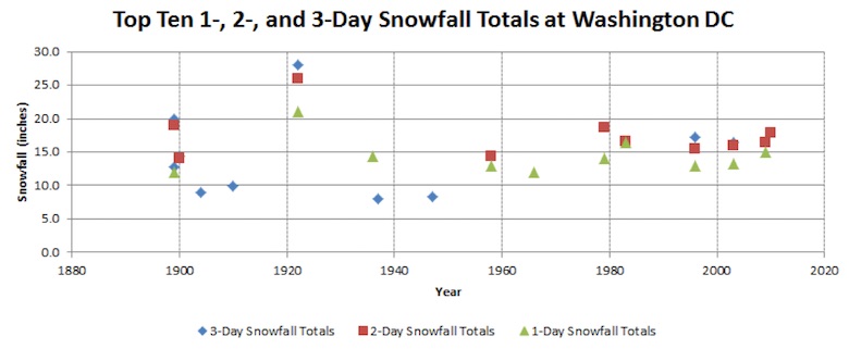
Figure 2. D.C.’s top 1-, 2-, and 3-day winter storms, plotted by total snow amount and year. Image credit: NWS/Baltimore-Washington.
What are D.C.’s biggest storms on record?
Among the largest East Coast cities, models are suggesting that Washington has the best shot at a potential record storm. Only one storm since D.C. records began in 1884 has managed to rack up more than 20”, whereas Baltimore has had eight such storms and Dulles four. See the statistics page put together by NWS/Baltimore-Washington for more details.
Top five D.C. snowstorms over periods of up to 3 days
28” (Jan. 27-29, 1922)
20” (Feb. 12-14, 1899)
18.7” (Feb. 18-19, 1979)
17.8 (Feb. 5-6, 2010)
17.1” (Jan. 6-8, 1996)As this storm approaches, the NWS/Baltimore-Washington office will provide experimental snowfall guidance in the form of maps and tables with detailed probabilities of exceeding various snow-amount thresholds. We can expect to see more of this type of guidance in the future; although it offers a lot of detail to parse, it provides a much richer guide to both the high- and low-end possibilities. For a reliable source of frequently updated, hyper-local coverage, you can’t beat Capital Weather Gang. Though it’s too soon to know exactly how this storm will behave, it’s not too soon to begin common-sense preparations if you’re anywhere in or near the target area.
Jeff and I will have a post Wednesday evening on the NASA/NOAA climate report for 2015, and I’ll have more on the looming East Coast storm on Thursday.
Beautiful cold air advection clouds off east coast today thanks 2 strong NW winds. Winds will shift b4 nor’easter. pic.twitter.com/Jj0SToQiFk
— Kathryn Prociv (@KathrynProciv) January 19, 2016