Last month’s seasonal total was higher than any since 1767 and three times the average level
Flooding beside the River Avon in central Bristol on 1 February. Photograph: Ben Birchall/PA
– January was England’s wettest winter month in almost 250 years (Guardian, Feb 1, 2014):
The deluge that has engulfed southern and central England in recent weeks is the worst winter downpour in almost 250 years, according to figures from the world’s longest-running weather station.
The rainfall measured at the historic Radcliffe Meteorological Station at Oxford University in January was greater than for any winter month since daily recording began there in 1767, and three times the average amount.
The latest Met Office data shows that the region from Devon to Kent and up into the Midlands suffered its wettest January since its records began in 1910.
But Ian Ashpole, the Radcliffe Meteorological Observer, said: “The Radcliffe measurements more than double the length of the Met Office record and give us a better grip on how things are changing.”
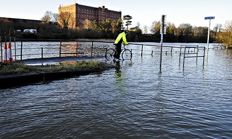
Flooding has been identified as the most dangerous impact of climate change for the UK and is hitting harder and faster than expected, according to scientists. Thousands of homes have been flooded since December, and much of the low-lying Somerset Levels remains under water.
Ashpole said: “The figures here are pretty representative of the broader area as all the weather stations in the region have been recording very high rainfall and the rain fronts have been coming in over broad areas.”
Oxford’s Radcliffe Observatory was founded to assist astronomers, but while the telescopes have now gone, the weather station has continued its work and now has one of the longest-running series of daily measurements in the world.
A total of 146.9mm of rain fell in January, smashing the previous record of 138.7mm in 1852. The new record is three times the average recorded for the month over the last two and a half centuries. It was also the wettest winter month – December, January or February – ever recorded, beating December 1914, when 143.3mm fell.
In addition, the 45-day period from 18 December saw more rain at Radcliffe than for any such period in the observatory record. The total of 231.28mm demolished the previous high of 209.4mm, which fell from 1 December 1914.
But Met Office forecaster Callum MacColl said the relentless series of brutal storms showed no sign of letting up: “There will be more wet and windy weather from the Atlantic this week. And the 15-day outlook sees the unsettled theme very much continuing.”
Andrew Barrett, a storm expert at the University of Reading, said: “The conditions are exactly right to bring wet weather across Britain. There’s effectively a storm factory over the Atlantic, caused by cold polar air pressing up against warm, tropical air, causing weather systems to form. These have then been steered across Britain by a strong jet stream.” Scientists are examining whether the melting of the Arctic ice cap, due to global warming, has led the jet stream to track further south, meaning more storms are channeled across the UK.
On Saturday, the Environment Agency had five severe flood warnings in place, indicating a danger to life, in parts of the south-west and the Midlands. There were also 156 standard flood warnings, meaning flooding was expected and that immediate action was required, with only the north-east region unaffected. The Met Office was also warning of severe weather along the entire west coast of England and Wales, where very strong winds were expected on Sunday, with the additional risk of large waves over-topping sea walls.